-
Laser Emission
The LIDAR scanner emits thousands to millions of laser pulses per second toward the target area or object.
-
Reflection
These pulses bounce off surfaces, such as buildings, ground, trees, or structures, and return to the sensor.
-
Time-of-Flight Measurement
The system measures the time it takes for each laser pulse to travel to the object and back. Since light travels at a constant speed, this time can be used to calculate the exact distance.
-
Position & Angle Tracking
As the scanner moves (or rotates), it records the angle and position of each pulse. When combined with GPS and IMU data (in mobile or aerial systems), the result is a complete 3D map of the scanned environment.
-
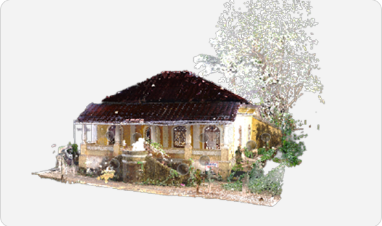
Step 5. Point Cloud Generation
All the measured points are compiled into a point cloud, a digital 3D representation of the scanned area. These can be further processed into 3D models, maps, or measurements.

Call us now
+91 98404 78347 | +91 7395972777
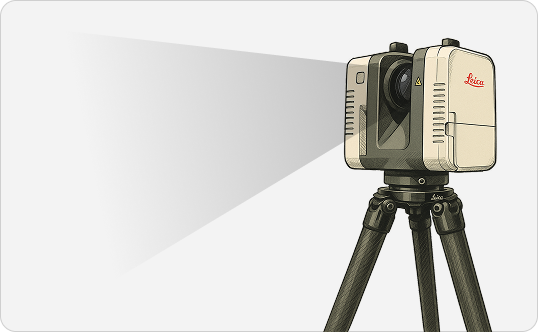
LIDAR Scanners
Long-range terrestrial laser 3D scanning with our advanced LIDAR 3D scanners.
Are you looking for a 3D scanner that can capture large environments with high accuracy and speed? A LIDAR scanner is the perfect choice.
3D Reality capture (Long range 3D scan )your Building, factory, plants, movie set, anything that is large

Email us
sm@precise3dm.com | sales@precise3dm.com
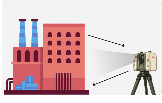
What is a LIDAR 3D scanner?
LIDAR (Light Detection and Ranging) technology uses laser light to measure distances with high accuracy. It captures the shape, position, and dimensions of buildings, plants, and environments by sending out rapid laser pulses and calculating how long they take to return after hitting a surface.

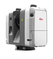
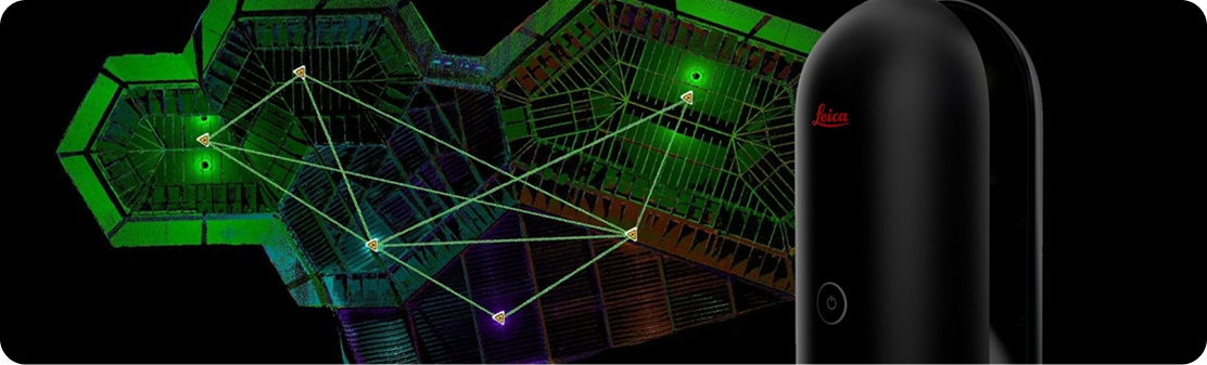
Lecia RTC360
Cutting-edge 3D laser scanner designed for fast and precise reality capture. It offers ultra-high-speed scanning, capturing up to 2 million points per second, and combines this with advanced HDR imaging to produce detailed, colour-rich 3D models.

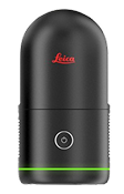
Lecia BLK360
A compact, lightweight, and user-friendly 3D laser scanner perfect for quick and easy reality capture. Despite its small size, it delivers impressive performance by capturing 360,000 points per second along with high-resolution panoramic images.
How does LIDAR technology work?
LIDAR technology uses laser pulses to measure distances and build accurate 3D
models of objects, terrain, or entire spaces, without requiring physical contact.
3D LIDAR Scanners from WildplantTS -Subsidy of Precise3DM
Precise 3DM is your 3D scanning partner for your manufacturing-based applications such as reverse engineering, 3d inspection and 3D printing.
We deal with metrology-related lidar laser scanning applications through Precise3DM. The needs of the plant engineering, architecture, and construction industries differ, and we have established a separate entity to meet their end-to-end needs.
WildPlantTS specialises in digital factories and building scanning applications for BIM / CIM. We have collaborated with Lica Geosystems to offer lidar scanners for building Construction and digital factory applications.
Types of Terrestrial LIDAR Scanners
Terrestrial LIDAR is a ground-based system used to capture the as-built condition of any physical environment, such as a building, construction site, or movie set, from a fixed or moving position on the Earth's surface. Types of terrestrial lidar scanners can be segmented by the deployment method
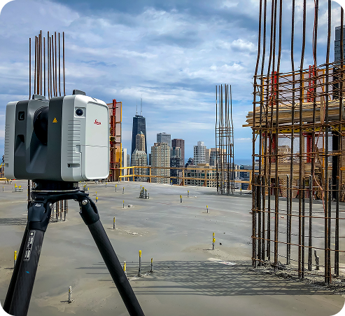
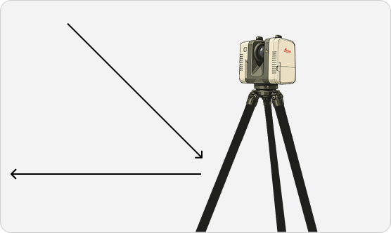
Static/Tripod LIDAR
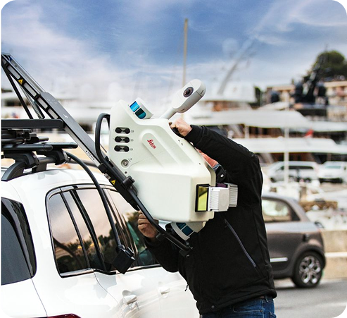
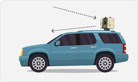
Mobile LIDAR
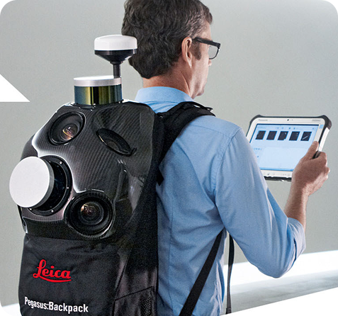
Backpack LIDAR

Handheld LIDAR
Applications of Terrestail Lidar 3D scanenrs
Building 3D Scanning for BIM model creation

Architectural 3D Scanning -For Refit and documentation
Construction Site 3D Scanning for Documentation ( For progress tracking and quality control)
As-Built Surveys with Laser Scanning: Creating accurate digital representations of existing structures.
Digital Twin Creation using 3D Scans: Focusing on the digital replica aspect for various industries.
Reality Capture for Facility Management: Using 3D scans for efficient facility operations.
Plant and Industrial 3D Laser Scanning for documentation, upgrades, and safety.
Topographic Surveys using 3D Laser Scanners: Modern surveying techniques for land mapping.
Infrastructure 3D Scanning: For bridges, tunnels, roads, and other infrastructure projects.
Historical Preservation 3D Scanning: Documenting heritage sites and artefacts.
Archaeological Site 3D Scanning: Creating detailed digital records of excavations.
Forensic Scene 3D Laser Scanning: Accurate documentation of crime scenes.
Virtual Tours from 3D Scans: Creating immersive experiences for real estate and other applications.
Dimensional Control with 3D Laser Scanning: Ensuring accuracy in manufacturing and Construction.
Clash Detection using 3D Scan Data: Identifying Interferences in Design and Construction.
Volume Calculation from 3D Laser Scans: For stockpiles and earthworks.
Deformation Monitoring with 3D Laser Scanning: Tracking changes in structures over time.
Reverse Engineering with long-range 3D Scanning: Creating CAD models from physical objects.
Digital Factory Planning with 3D Laser Scanning: Optimising layouts and processes.
Scan-to-BIM Workflow Solutions: Emphasising the integration with BIM software.
High-Speed 3D Laser Scanning Services: Highlighting the efficiency of the RTC360.
Colorised 3D Point Clouds: Featuring the visual richness of the scan data.
HDR Imaging with 3D Laser Scans: Highlighting the image quality.
Visualisation of Complex Environments using 3D Scans: For better understanding and communication.
Accurate 3D Measurements from Laser Scans: Emphasising the precision of the data.
360 Degree Laser Scanning Technology: Highlighting the comprehensive data capture.
Mobile Mapping with Leica RTC360: Although primarily static, its portability allows for mobile-like workflows in some scenarios.
Digital Documentation of Assets using 3D Scans: For asset management and lifecycle.
Creation of 3D Models from Point Clouds: The process of converting scan data into usable models.
FREQUENTLY ASKED QUESTIONS
LIDAR (Light Detection and Ranging) uses laser pulses to measure distances and generate high-accuracy 3D point clouds of real-world environments. Advanced systems can scan millions of points in seconds, enabling fast and accurate digital capture of areas.
Architecture, construction, civil engineering, heritage preservation, facility management, Factories and manufacturing are just a few sectors leveraging LIDAR to streamline documentation, design validation, and progress monitoring.
High-end LIDAR scanners can achieve sub-millimetre to millimeter, level accuracy, ideal for detailed documentation and modelling. The accuracy depends on the scanner's Quality and environmental conditions.
Yes, modern LIDAR scanners are designed for both environments.
Premium scanners can complete a full 360° scan in under two minutes. certain Lidar Scanner like Leica RTC360 can capture 2 million points per second, dramatically reducing field time without compromising data quality.
Today's LIDAR scanners come in compact, lightweight forms. Some similar to Leica BLK360 can even fit into a backpack and be set up in seconds, making them ideal for professionals who need quick mobility on-site.
Top-tier 3D Lidar Scanners come with intuitive software like Cyclone 3DR, Register 360 etc that automates registration and simplifies workflows. Automatic alignment features like VIS help to save hours of post-processing, especially useful in high-volume scan projects.
Yes. Many Lidar scanners offer built-in HDR cameras that capture realistic, colorized 3D scans along with Real Photos, ideal for immersive visualization, documentation, and presentations.
Terrestrial scanners are ideal for capturing large environments with high accuracy, while handheld units are better suited for small or confined areas. Terrestrial LIDAR is better option for professional usage
LIDAR enables fast site documentation, clash detection, progress tracking, and deviation analysis. By capturing accurate as-built data, it helps reduce rework and ensure project alignment.
Basic training from an Authorized LIDAR Scanner distributor is recommended, but many user-friendly models are designed with guided workflows and touchscreen interfaces, enabling even non-experts to start scanning quickly and confidently.
Yes, certain advanced scanners support real-time data registration and visualization on a tablet or mobile device, allowing users to verify scan completeness before leaving the site.
Most scanners export industry-standard formats like E57, LAS, PTS, and OBJ, ensuring compatibility with popular CAD, BIM, and visualization software.
Consider your project scale, accuracy requirements, portability, and workflow speed. Solutions like the Leica RTC360 offer automated registration and high-speed capture for large projects, while the BLK360 is perfect for users needing a compact and easy-to-use scanner with rich visual outputs.